060
WTNT32 KNHC 261747
TCPAT2
BULLETIN
Tropical Storm Kirk Intermediate Advisory Number 11A
NWS National Hurricane Center Miami FL AL122018
200 PM AST Wed Sep 26 2018
…KIRK STRENGTHENS SOME MORE BUT LITTLE ADDITIONAL CHANGE IN
STRENGTH EXPECTED THROUGH THURSDAY…
SUMMARY OF 200 PM AST…1800 UTC…INFORMATION
———————————————-
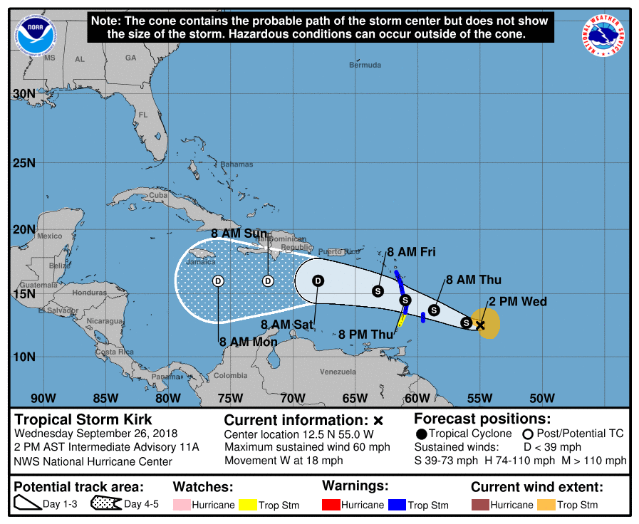
LOCATION…12.5N 55.0W
ABOUT 305 MI…495 KM E OF BARBADOS
ABOUT 430 MI…695 KM ESE OF MARTINIQUE
MAXIMUM SUSTAINED WINDS…60 MPH…95 KM/H
PRESENT MOVEMENT…W OR 280 DEGREES AT 18 MPH…30 KM/H
MINIMUM CENTRAL PRESSURE…998 MB…29.47 INCHES
WATCHES AND WARNINGS
——————–
CHANGES WITH THIS ADVISORY:
None.
SUMMARY OF WATCHES AND WARNINGS IN EFFECT:
A Tropical Storm Warning is in effect for…
* Barbados
* St. Lucia
* Dominica
* Martinique
* Guadeloupe
A Tropical Storm Watch is in effect for…
* St. Vincent and the Grenadines
A Tropical Storm Warning means that tropical storm conditions are
expected somewhere within the warning area within 36 hours.
A Tropical Storm Watch means that tropical storm conditions are
possible within the watch area, in this case within 36 hours.
Interests elsewhere in the central and northern Lesser Antilles
should monitor the progress of Kirk as additional warnings or
watches could be issued later today.
For storm information specific to your area, please monitor
products issued by your national meteorological service.

DISCUSSION AND OUTLOOK
———————-
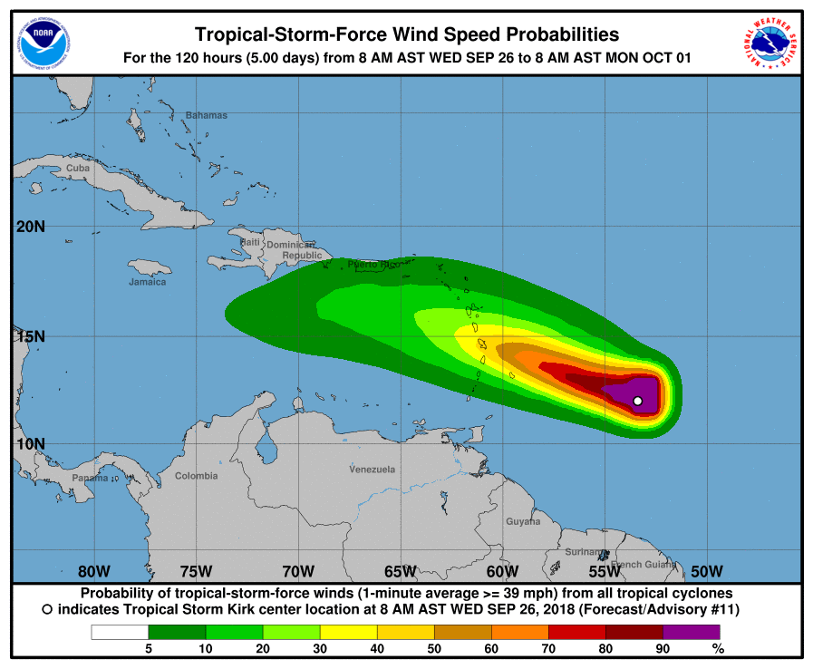
At 200 PM AST (1800 UTC), the center of Tropical Storm Kirk was
located near latitude 12.5 North, longitude 55.0 West. Kirk is
moving toward the west near 18 mph (30 km/h). A westward to
west-northwestward motion is expected over the next few days. On
the forecast track, the center will move over the Lesser Antilles
within the Tropical Storm Warning area Thursday night.
Reports from an Air Force Hurricane Hunter aircraft indicate that
the maximum sustained winds have increased to near 60 mph (95 km/h)
with higher gusts. Little change in strength is forecast until Kirk
crosses the Lesser Antilles, followed by weakening over the eastern
Caribbean Sea.
Tropical-storm-force winds extend outward up to 115 miles (185 km)
from the center.
The minimum central pressure estimated from Air Force Hurricane
Hunter observations is 998 mb (29.47 inches).
HAZARDS AFFECTING LAND
———————-
WIND: Tropical storm conditions are expected to first reach the
warning area by Thursday afternoon, making outside preparations
difficult or dangerous. Tropical storm conditions are possible
within the watch area by Thursday afternoon or evening.
RAINFALL: Kirk is expected to produce total rainfall of 4 to 6
inches across the northern Windward and southern Leeward Islands
with isolated maximum totals up to 10 inches across Martinique and
Dominica. These rains may produce life-threatening flash floods and
mudslides.
NEXT ADVISORY
————-
Next complete advisory at 500 PM AST.
$$
Forecaster Pasch


