196
WTNT32 KNHC 270250
TCPAT2
BULLETIN
Tropical Storm Kirk Advisory Number 13
NWS National Hurricane Center Miami FL AL122018
1100 PM AST Wed Sep 26 2018
…HURRICANE HUNTER AIRCRAFT FINDS KIRK A LITTLE WEAKER…
…TROPICAL STORM CONDITIONS EXPECTED ACROSS PORTIONS OF THE
WINDWARD AND LEEWARD ISLANDS ON THURSDAY…
SUMMARY OF 1100 PM AST…0300 UTC…INFORMATION
———————————————–
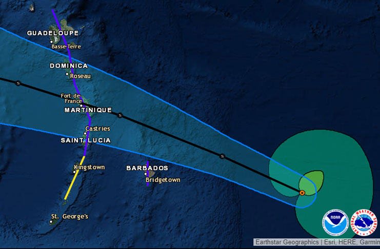
LOCATION…13.0N 57.0W
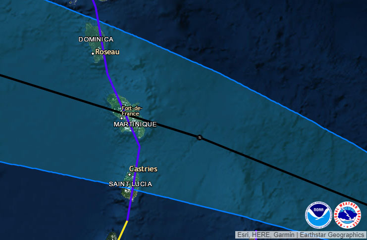
ABOUT 170 MI…270 KM E OF BARBADOS
ABOUT 295 MI…470 KM ESE OF MARTINIQUE
MAXIMUM SUSTAINED WINDS…50 MPH…85 KM/H
PRESENT MOVEMENT…WNW OR 285 DEGREES AT 16 MPH…26 KM/H
MINIMUM CENTRAL PRESSURE…1002 MB…29.59 INCHES
WATCHES AND WARNINGS
——————–
CHANGES WITH THIS ADVISORY:
None.
SUMMARY OF WATCHES AND WARNINGS IN EFFECT:
A Tropical Storm Warning is in effect for…
* Barbados
* St. Lucia
* Dominica
* Martinique
* Guadeloupe
A Tropical Storm Watch is in effect for…
* St. Vincent and the Grenadines

A Tropical Storm Warning means that tropical storm conditions are
expected somewhere within the warning area, in this case within 24
hours.
A Tropical Storm Watch means that tropical storm conditions are
possible within the watch area, in this case within 24 hours.
Interests elsewhere in the central and northern Lesser Antilles
should monitor the progress of Kirk as additional warnings or
watches could be issued tonight.
For storm information specific to your area, please monitor
products issued by your national meteorological service.
DISCUSSION AND OUTLOOK
———————-
At 1100 PM AST (0300 UTC), the center of Tropical Storm Kirk was
located by Air Force Reserve Hurricane Hunter aircraft near latitude
13.0 North, longitude 57.0 West. Kirk is moving toward the
west-northwest near 16 mph (26 km/h), and this general motion is
expected to continue over the next few days. On the forecast
track, the center of Kirk will move across the Lesser Antilles
within the tropical storm warning area Thursday or Thursday
evening.
Data from the Hurricane Hunter plane indicate that maximum sustained
winds have decreased to near 50 mph (85 km/h) with higher gusts.
Gradual weakening is anticipated during the next couple of days,
but Kirk is forecast to move across the Lesser Antilles and into
the eastern Caribbean Sea as a tropical storm.
Tropical-storm-force winds extend outward up to 140 miles (220 km)
mainly to the north and east of the center.
The minimum central pressure based on the latest aircraft data is
1002 mb (29.59 inches).
HAZARDS AFFECTING LAND
———————-
WIND: Tropical storm conditions are expected to first reach the
warning area by Thursday afternoon, making outside preparations
difficult or dangerous. Tropical storm conditions are possible
within the watch area by Thursday afternoon.
RAINFALL: Kirk is expected to produce total rainfall of 4 to 6
inches across the northern Windward and southern Leeward Islands
with isolated maximum totals up to 10 inches across Martinique and
Dominica. These rains may produce life-threatening flash floods and
mudslides. Across eastern Puerto Rico, Kirk is expected to bring 2
to 4 inches with isolated maximum totals of 6 inches by Friday and
Saturday.
NEXT ADVISORY
————-
Next intermediate advisory at 200 AM AST.
Next complete advisory at 500 AM AST.
$$
Forecaster Berg


