657
WTNT32 KNHC 272355
TCPAT2
BULLETIN
Tropical Storm Kirk Intermediate Advisory Number 16A
NWS National Hurricane Center Miami FL AL122018
800 PM AST Thu Sep 27 2018
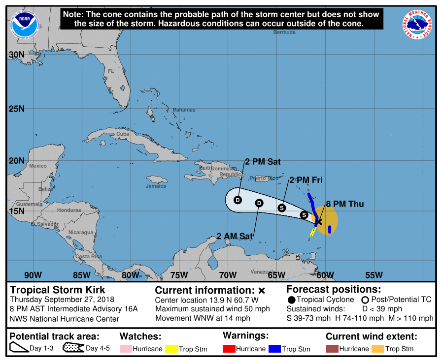
…CENTER OF KIRK APPROACHING ST. LUCIA…
…HEAVY SHOWERS AND THUNDERSTORMS BEGINNING TO SPREAD ACROSS
BARBADOS…
SUMMARY OF 800 PM AST…0000 UTC…INFORMATION
———————————————-
LOCATION…13.9N 60.7W
ABOUT 15 MI…25 KM E OF ST. LUCIA
ABOUT 60 MI…95 KM SSE OF MARTINIQUE
MAXIMUM SUSTAINED WINDS…50 MPH…85 KM/H
PRESENT MOVEMENT…WNW OR 290 DEGREES AT 14 MPH…22 KM/H
MINIMUM CENTRAL PRESSURE…1002 MB…29.59 INCHES
WATCHES AND WARNINGS
——————–
CHANGES WITH THIS ADVISORY:
None.
SUMMARY OF WATCHES AND WARNINGS IN EFFECT:
A Tropical Storm Warning is in effect for…
* Barbados
* St. Lucia
* Dominica
* Martinique
* Guadeloupe
A Tropical Storm Watch is in effect for…
* St. Vincent and the Grenadines
Interests elsewhere in the central and northern Lesser Antilles
should monitor the progress of Kirk.
For storm information specific to your area, please monitor
products issued by your national meteorological service.
DISCUSSION AND OUTLOOK
———————-
At 800 PM AST (0000 UTC), the center of Tropical Storm Kirk was
located by an Air Force Reserve Hurricane Hunter aircraft just east
of St. Lucia near latitude 13.9 North, longitude 60.7 West. Kirk is
moving toward the west-northwest near 14 mph (22 km/h). A west-
northwestward to westward motion is expected over the next couple of
days. On the forecast track, the center of Kirk will move across
the Lesser Antilles within the Tropical Storm Warning area during
the next several hours.
Maximum sustained winds are near 50 mph (85 km/h) with higher
gusts. Little change in strength is expected while the center of
Kirk moves through the Lesser Antilles. Gradual weakening is
anticipated during the next couple of days while the system moves
over the eastern Caribbean Sea. Kirk is forecast to become a
tropical depression Friday night, and degenerate into a trough of
low pressure by Sunday.
Tropical-storm-force winds extend outward up to 140 miles (220 km)
primarily to the east of the center.
The minimum central pressure based on data from the aircraft is 1002
mb (29.59 inches).
HAZARDS AFFECTING LAND
———————-
WIND: Tropical storm conditions are expected to begin in portions
of the warning area during the next few hours. Tropical storm
conditions are possible within the watch area overnight. Locally
higher winds are possible atop and on the windward sides of hills
and mountains.
RAINFALL: Kirk is expected to produce total rainfall of 4 to 6
inches across the northern Windward and southern Leeward Islands
with isolated maximum totals up to 10 inches across Martinique and
Dominica. These rains may produce life-threatening flash floods and
mudslides. Across Saint Croix and eastern Puerto Rico, Kirk is
expected to bring 2 to 4 inches with isolated maximum totals of 6
inches by Friday and Saturday.
NEXT ADVISORY
————-
Next complete advisory at 1100 PM AST.
$$
Forecaster Berg


