Tropical Storm Gonzalo Intermediate Advisory 13A
…GONZALO CONTINUES WESTWARD…
…FORECAST TO BRING GUSTY WINDS AND HEAVY RAIN TO PORTIONS
OF THE SOUTHERN WINDWARD ISLANDS BEGINNING SATURDAY…
LOCATION…10.0N 56.3W
ABOUT 340 MI…550 KM E OF THE SOUTHERN WINDWARD ISLANDS
MAXIMUM SUSTAINED WINDS…40 MPH…65 KM/H
PRESENT MOVEMENT…W OR 270 DEGREES AT 18 MPH…30 KM/H
MINIMUM CENTRAL PRESSURE…1008 MB…29.77 INCHES
WATCHES AND WARNINGS
——————–
CHANGES WITH THIS ADVISORY…
The government of Barbados has discontinued the Tropical Storm
Warning for Barbados.
SUMMARY OF WATCHES AND WARNINGS IN EFFECT…
A Tropical Storm Warning is in effect for…
* St. Vincent and the Grenadines
* Tobago
* Grenada and its dependencies
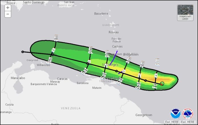
At 800 PM AST (0000 UTC), the center of Tropical Storm Gonzalo was
located near latitude 10.0 North, longitude 56.3 West. Gonzalo is
moving toward the west near 18 mph (30 km/h). A general westward to
west-northwestward motion is expected for the next couple of days.
On the forecast track, Gonzalo will move across the southern
Windward Islands Saturday afternoon or evening and over the eastern
Caribbean Sea on Sunday.
Maximum sustained winds are near 40 mph (65 km/h) with higher
gusts. Some slight strengthening is possible before Gonzalo reaches
the southern Windward Islands. Weakening is expected after Gonzalo
moves over the eastern Caribbean Sea and the system is forecast to
dissipate early next week.
Tropical-storm-force winds extend outward up to 25 miles (35 km)
from the center.
The estimated minimum central pressure is 1008 mb (29.77 inches).
Gonzalo is expected to produce total rain accumulations
of 2 to 5 inches, with isolated maximum amounts of 8 inches in
Barbados and the Windward Islands through Sunday night. Gonzalo is
also expected to produce total rain accumulations of 2 to 4 inches
in Trinidad and Tobago as well as 1 to 2 inches over northeastern
Venezuela. Rainfall in Barbados and the Windward Islands could lead
to life-threatening flash floods.


