ZCZC MIATWOAT ALL
TTAA00 KNHC DDHHMM
Tropical Weather Outlook
NWS National Hurricane Center Miami FL
800 AM EDT Tue Sep 25 2018
For the North Atlantic…Caribbean Sea and the Gulf of Mexico:
The National Hurricane Center is issuing advisories on Subtropical
Depression Leslie, located a little over 1100 miles west-southwest
of the Azores.

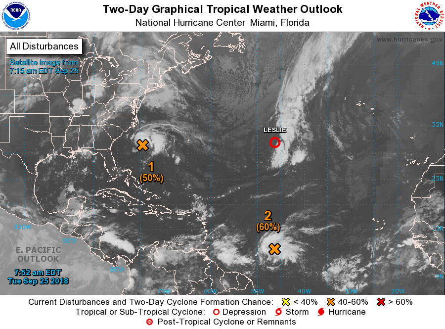
1. A broad area of low pressure located about 260 miles south of Cape
Hatteras, North Carolina, continues to produce showers and
thunderstorms on its north side. Satellite and surface data
indicate that the circulation of the low is elongated and not well
organized. However, this system could still become a tropical
depression later today while it moves northwestward. By tonight and
Wednesday, additional development appears unlikely, due to strong
upper-level winds, while the system moves northward and
north-northeastward near the southeastern United States coast.
Regardless of tropical cyclone formation, this system is likely to
bring scattered showers and thunderstorms across portions of
northeastern South Carolina and eastern North Carolina later today
and tonight. In addition, dangerous surf conditions and rip
currents are expected along portions of the North Carolina coast
today. For more information, please see products from your local
National Weather Service office.
* Formation chance through 48 hours…medium…50 percent.
* Formation chance through 5 days…medium…50 percent.
2. The remnants of Kirk are located about 950 miles east of the
Windward Islands and are moving quickly westward at around 25 mph.
This system continues to produce a large area of showers and
thunderstorms, along with winds to near gale force in gusts on its
north side. However, satellite data indicate that the system still
lacks a closed circulation. This disturbance could redevelop into a
tropical cyclone during the next day or two before it moves
into an area of highly unfavorable upper-level winds while it
approaches the Caribbean Sea. Interests in the Windward and
Leeward Islands should monitor the progress of this disturbance as
gusty winds and locally heavy rains are likely over the next couple
of days even if the system does not redevelop into a tropical
cyclone. For more information on this system, see High Seas
Forecasts issued by the National Weather Service.
* Formation chance through 48 hours…medium…60 percent.
* Formation chance through 5 days…medium…60 percent.
3. Subtropical Depression Leslie is forecast to become post-tropical
today after it merges with a cold front over the central Atlantic.
After that time, Leslie is expected to reacquire subtropical or
tropical characteristics by the end of the week as it meanders over
the central Atlantic.
* Formation chance through 48 hours…low…near 0 percent.
* Formation chance through 5 days…high…70 percent.
High Seas Forecasts issued by the National Weather Service can be
found under AWIPS header NFDHSFAT1, WMO header FZNT01 KWBC, and
on the Web at https://ocean.weather.gov/shtml/NFDHSFAT1.shtml.
Forecaster Pasch


