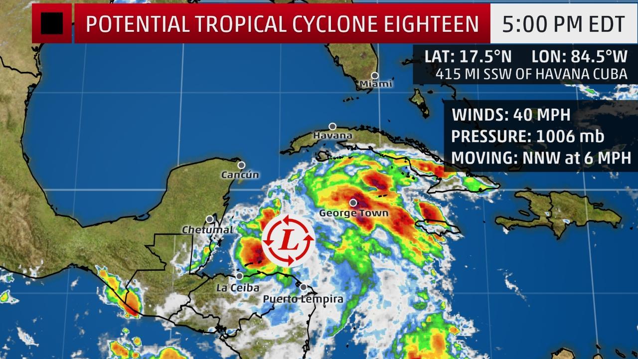
NEMO and the National Met Service hereby inform the general public that as at 2:00 p.m., showers and thunderstorms associated with a broad Area of Low Pressure (93L) located over the northwestern Caribbean Sea are beginning to show signs of organization. The broad Area of Low Pressure (93L) has a medium to high chance of development into a tropical cyclone within the next 48 hours. Conditions are expected to be conducive, and a tropical depression or tropical storm is likely to form later today or Saturday as the system moves northward over the north-western Caribbean Sea before turning north eastward by late Saturday. The Area of Low Pressure (93L) is currently located east of Belize near 17.5 North Latitude and 84.5 West Longitude. The models are all in consensus for this potential system to move northwards and then north-eastward away from Belize. It is currently moving slowly northward towards Jamaica and Cuba, and is forecasted to continue track towards the Bahamas over the weekend. At this time the Area of Low Pressure (93L) DOES NOT pose a threat to Belize. Most of the heavy winds and rains are on the eastern side of the system, over the sea.
NEMO and the National Met Service are also monitoring Tropical Storm SELMA in the south-eastern Pacific Ocean. SELMA is expected to churn north-ward this weekend and to move over Guatemala and threaten parts of Central America with deadly flash floods. SELMA is expected to make landfall Saturday
near the border of El Salvador and Guatemala. If the storm tracks farther to the west into central or western Guatemala, near to but not to crossing over Belize, landfall may not occur until later in the afternoon or evening. While the warm Pacific Ocean may allow SELMA to become slightly stronger, its short time over these waters is expected to prevent rapid intensification. Flooding, rain and mudslides are likely to threaten lives and property in parts of Central America, regardless of SELMA’s strength.
Moreover, moisture ahead of this system will cause our weather to become moist and unstable giving way to an increase in showers over most areas but more so over central and southern Belize. As much as 4-8 inches of rain is expected over El Salvador and eastern Guatemala, of which some could affect central and southern Belize. There is a potential for flood in the south and other flood prone areas during Saturday night into early Sunday morning. Over the weekend, people, especially in central and southern Belize need to be prepared for possible heavy rainfall and flash floods. Also, historically around this time
tropical cyclones have known to be unpredictable.
FLOOD TIPS: Keep drains clean. DO NOT swim and play in flood waters, fast flowing water six inches high can sweep you off your feet. People in low-lying areas are always advised, as necessary, to move to shelter in higher grounds. Stay away from rivers and streams. DO NOT attempt to cross flooded rivers.
DO NOT touch electrical fixtures and equipment when in flood waters. Turn off power at the main switch box before your home is flooded. Drivers are reminded to exercise caution when driving in wet conditions; reduce speed, put on your low beam and hazard lights. It is not advisable to drive through flood waters.
NEMO’s Emergency Coordinators can be reached as follows:
Corozal, Mr.Williard Levy at 623 0237;
Orange Walk, Ms. Suliema Celiz at 605 5046, or Mr. Aragon at 636 6094;
Belize District, Mr. Lionel Tillett at 6154834 and Mr. Kevin Pollard at 621 2275;
San Pedro, Ms. Vanessa Parham at 632 3698;
Belize City, Ms.Timrose Augustine at 600 8672 and Councillor Philip Willoughby at 615 9793;
Belmopan, Ms. Clare Moody at 630 9791;
Cayo, Mr. Al Westby at 630 3224 or Mr. Johnny Ramclam at 625 2526;
Stann Creek, Mr. Keith Emmanuel at 615 9711; and
Toledo, Mr. Kenton Parham at 630 9787.
The NEMO Emergency Hotline is 936.
NEMO AND THE NATIONAL MET SERVICE OF BELIZE WILL CONTINUE TO MONITOR BOTH SYSTEMS. THE PUBLIC IS ADVISED NOT TO ACT ON RUMOURS IN RESPONSE TO THE SITUATION.

Tropical Cyclones Activity in Our Region
Must Read
Agriculture Sector Webinar Series for 2025 hurricane season
CARICOM Secretariat hosts Webinar series aims to prepare agriculture sector for 2025 hurricane season
With the hurricane season approaching (June - November), the CARICOM Secretariat...


