968
WTNT34 KNHC 110243
TCPAT4
BULLETIN
Tropical Storm Isaac Advisory Number 14
NWS National Hurricane Center Miami FL AL092018
1100 PM AST Mon Sep 10 2018
…ISAAC A LITTLE WEAKER…
…STILL EXPECTED TO BE AT OR NEAR HURRICANE STRENGTH WHEN IT
APPROACHES THE LEEWARD ISLANDS LATER THIS WEEK…
SUMMARY OF 1100 PM AST…0300 UTC…INFORMATION
———————————————–
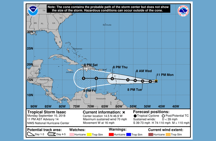
LOCATION…14.5N 46.9W
ABOUT 960 MI…1550 KM E OF THE LESSER ANTILLES
MAXIMUM SUSTAINED WINDS…70 MPH…110 KM/H
PRESENT MOVEMENT…W OR 270 DEGREES AT 16 MPH…26 KM/H
MINIMUM CENTRAL PRESSURE…997 MB…29.44 INCHES
WATCHES AND WARNINGS
——————–
There are no coastal watches or warnings in effect.
Interests in the Lesser Antilles should monitor the progress of
Isaac.
DISCUSSION AND OUTLOOK
———————-
At 1100 PM AST (0300 UTC), the center of Tropical Storm Isaac was
located near latitude 14.5 North, longitude 46.9 West. Isaac is
moving toward the west near 16 mph (26 km/h). This general motion is
expected to continue through the end of the week. On the forecast
track, Isaac should move across the Lesser Antilles and into the
eastern Caribbean Sea on Thursday.
The maximum sustained winds have decreased to near 70 mph (110
km/h) with higher gusts. Little change in strength is forecast
during the next few days, but Isaac is forecast to be at or near
hurricane strength as it approaches the Lesser Antilles later this
week.
Tropical-storm-force winds extend outward up to 45 miles (75 km)
from the center.
The estimated minimum central pressure is 997 mb (29.44 inches).
HAZARDS AFFECTING LAND
———————-
RAINFALL: Isaac is expected to produce total rainfall accumulations
of 2 to 4 inches with isolated amounts near 6 inches across the
Leeward Islands late this week, with 1 to 2 inches anticipated
across the Windward Islands.
NEXT ADVISORY
————-
Next complete advisory at 500 AM AST.
$$
Forecaster Zelinsky


