146
WTNT32 KNHC 271451
TCPAT2
BULLETIN
Tropical Storm Kirk Advisory Number 15
NWS National Hurricane Center Miami FL AL122018
1100 AM AST Thu Sep 27 2018
…KIRK NEARING THE LESSER ANTILLES…
SUMMARY OF 1100 AM AST…1500 UTC…INFORMATION
———————————————–
LOCATION…13.8N 59.3W
ABOUT 45 MI…70 KM NNE OF BARBADOS
ABOUT 130 MI…210 KM ESE OF MARTINIQUE
MAXIMUM SUSTAINED WINDS…50 MPH…85 KM/H
PRESENT MOVEMENT…WNW OR 290 DEGREES AT 15 MPH…24 KM/H
MINIMUM CENTRAL PRESSURE…999 MB…29.50 INCHES
WATCHES AND WARNINGS
——————–
CHANGES WITH THIS ADVISORY:
None.
SUMMARY OF WATCHES AND WARNINGS IN EFFECT:
A Tropical Storm Warning is in effect for…
* Barbados
* St. Lucia
* Dominica
* Martinique
* Guadeloupe
A Tropical Storm Watch is in effect for…
* St. Vincent and the Grenadines
Interests elsewhere in the central and northern Lesser Antilles
should monitor the progress of Kirk.
For storm information specific to your area, please monitor
products issued by your national meteorological service.
DISCUSSION AND OUTLOOK
———————-
At 1100 AM AST (1500 UTC), the center of Tropical Storm Kirk was
located near latitude 13.8 North, longitude 59.3 West. Kirk is
moving toward the west-northwest near 15 mph (24 km/h), and this
general motion with a slight decrease in forward speed is expected
over the next few days. On the forecast track, the center of Kirk
will move across the Lesser Antilles within the Tropical Storm
Warning area by this evening.
Maximum sustained winds are near 50 mph (85 km/h) with higher gusts.
Gradual weakening is anticipated during the next couple of days, but
Kirk is forecast to move across the Lesser Antilles and into the
eastern Caribbean Sea as a tropical storm.
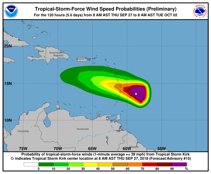
Tropical-storm-force winds extend outward up to 140 miles (220 km)
from the center.
The minimum central pressure estimated from Air Force Hurricane
Hunter observations is 999 mb (29.50 inches).
HAZARDS AFFECTING LAND
———————-
WIND: Tropical storm conditions are expected to first reach the
warning area this afternoon, making outside preparations difficult
or dangerous. Tropical storm conditions are possible within the
watch area by this afternoon.
RAINFALL: Kirk is expected to produce total rainfall of 4 to 6
inches across the northern Windward and southern Leeward Islands
with isolated maximum totals up to 10 inches across Martinique and
Dominica. These rains may produce life-threatening flash floods and
mudslides. Across eastern Puerto Rico, Kirk is expected to bring 2
to 4 inches with isolated maximum totals of 6 inches by Friday and
Saturday.
NEXT ADVISORY
————-
Next intermediate advisory at 200 PM AST.
Next complete advisory at 500 PM AST.
$$
Forecaster Pasch


